A Chinese firm published detailed satellite imagery of U.S. military deployments before the Iran strikes. The catch: the images came from American companies.
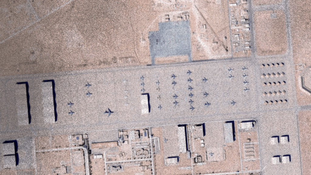
In late February 2026, a Chinese company called MizarVision began circulating annotated satellite imagery on Weibo showing U.S. military deployments across the Middle East in precise detail. Eleven F-22 stealth fighters on the runway at Ovda Air Base in Israel. Eighteen F-35s and six EA-18G Growler electronic warfare aircraft at Muwaffaq Salti Air Base in Jordan. KC-135 refueling tankers, C-17 transports, E-3C early warning aircraft at Prince Sultan Air Base in Saudi Arabia. Patriot batteries. Logistics depots. Naval positioning. Change detection over days.
The framing that went viral was predictable: China had handed Iran a targeting map. Beijing had delivered a military dossier to Tehran. Chinese intelligence was openly aiding the adversary.
It spread because it confirmed a story people already had. It was also, in its most alarming details, wrong.
Hu Bo, Director of the South China Sea Probing Initiative at Peking University and one of China’s leading satellite imagery analysts, says he is “100 percent sure” the images MizarVision circulated came not from Chinese satellites but from U.S. and European commercial providers. A MizarVision representative confirmed the company sources imagery from “diverse” providers including Western commercial entities. At high resolution — the approximately 0.3-meter imagery used to identify individual aircraft — the source appears to be Vantor, formerly Maxar Intelligence, a U.S. company. Wide-swath maritime imagery came from Planet, another U.S. firm.
What MizarVision contributed was not access to classified Chinese reconnaissance. It was AI-driven object detection, annotation, change tracking over time, and theatrical repackaging for Weibo distribution. The company identified aircraft types, counted assets, flagged Patriot battery positions, and produced graphics. The underlying imagery was commercially sold, globally available, and in significant part American in origin.
This is the actual story. And it is more consequential than the espionage narrative.
What MizarVision Actually Did
MizarVision is a five-year-old Hangzhou-based firm. Its website states in English: “Why We’re Here: Finding answers, shaping tomorrow.” It has been tracking U.S. force movements in the Middle East since the pre-strike buildup began, publishing regular updates on aircraft types and quantities, air defense system positions, and logistics patterns across Qatar, Jordan, Saudi Arabia, Israel, Diego Garcia, and Crete.
The People’s Liberation Army amplified the effort separately, via its official social media platform China Military Bugle, releasing a video titled “Siege of Iran: where will the US military launch its attack in the Middle East?” — featuring high-resolution imagery of eight U.S. bases it described as under surveillance. The PLA video highlighted Patriot air defense systems at Al Udeid, Al Dhafra, and Prince Sultan Air Bases pointed toward Iran.
Notably, MizarVision omitted one base from its published tranche: Al Dhafra in the UAE, which hosts the U.S. 380th Air Expeditionary Wing and is one of the most significant U.S. air power hubs in the region. Aviation Week noted the omission without explanation. Whether it was a gap in imagery coverage, a deliberate signal of restraint, or something else is not established.
A retired Chinese colonel quoted by South China Morning Post described MizarVision’s monitoring as representing China’s development as “an intelligence powerhouse.” A military commentator called it “demonstrating capability and advertising.” That framing — capability demonstration and advertising — is more accurate than the espionage framing. This was performance as much as intelligence.
The Western Companies Selling the View
The most important fact in the viral story is the one the viral story omitted: the imagery that exposed U.S. deployments came from American and European commercial satellite companies.
This is not incidental. The commercial remote sensing industry — dominated by U.S. firms like Planet and Maxar — sells high-resolution imagery of the entire earth’s surface to anyone who will pay. That commercial market was built and expanded under U.S. regulatory decisions that progressively permitted higher resolution imagery for commercial sale, driven by economic interest and the lobbying power of an industry that generates significant revenue from government and private clients alike.
The U.S. military is itself a major customer of these commercial providers. It funds them, contracts with them, and relies on their imagery for its own situational awareness. The infrastructure that enabled MizarVision to document American F-22 deployments in southern Israel is, in substantial part, infrastructure that American capital built and American policy permitted.
This is not a paradox. It is the logic of capital applied to surveillance. Imagery capability was commercialized because it was profitable. The downstream consequence — that adversary states and their contractors can purchase detailed documentation of U.S. military posture — was accepted as a trade-off. That trade-off is now visible in the Middle East, in real time, during an active war.
Why the Annotations Matter Even If the Secrets Don’t
The espionage framing is wrong, but the “nothing to see here” counter-narrative is also incomplete.
Open-source intelligence has a practical floor and a practical ceiling. The floor is this: anyone with a credit card and analytical patience can approximate what MizarVision produced. Le Monde independently analyzed high-resolution imagery from Planet to identify U.S. fighter deployments in Jordan. Hobbyist OSINT accounts track aircraft carrier movements in near-real time. The raw capability is genuinely democratized.
The ceiling is this: not all actors can do what MizarVision does at speed and at scale. AI-driven object detection that counts aircraft types in minutes, tracks asset changes across a dozen bases over days, identifies Patriot battery configurations and radar vehicle positions — that is not hobbyist work. It is a productized analytical pipeline. The South China Morning Post asked whether China is “flexing its intelligence muscle” by tracking U.S. military moves near Iran. The honest answer is: it is demonstrating the productization of a capability that Western commercial infrastructure made possible, and redeploying it for information warfare purposes.
What changed is not that the information became available. What changed is that the information became structured, packaged, and amplified through a state-affiliated distribution network during the week before a war began. The PLA video. The MizarVision Weibo posts. The Global Times coverage. These are not independent coincidences. They are a coordinated information operation using commercially available inputs.
Visibility as a Strategic Instrument
The function of what China did is not primarily informational. Iran’s military planners have their own surveillance capabilities, their own network of intelligence, and access to the same commercial imagery markets. They did not need MizarVision to know that F-22s were at Ovda.
The function was signaling — to multiple audiences simultaneously.
To Iran: you are not alone in monitoring this buildup, and your adversary’s deployments are not invisible.
To the United States: your force movements are being tracked, documented, and published, and we are demonstrating that capability publicly.
To the broader international audience: the unilateral, unaccountable nature of American military projection — bases across a dozen countries, aircraft carriers positioned for strikes, Patriot batteries pointed at a sovereign state — is not a secret. It is a visible, documented, global infrastructure of coercion.
That last audience is the most important one for understanding what this episode actually is. The MizarVision releases are part of a broader Chinese information strategy that uses publicly available evidence to build a counter-narrative about American militarism. It does not require classified intelligence to make that argument. The commercial satellite record is sufficient.
This is deterrence through exposure. Not deterrence through weapons, but deterrence through documentation. When military buildup becomes globally trackable and socially shareable, the political cost of that buildup increases. The psychological environment shifts, not necessarily toward peace, but toward a world in which the infrastructure of empire has to be defended in public rather than obscured in secrecy.
The Surveillance Ecosystem and Who It Serves
The deeper question the MizarVision episode poses is about the commercial surveillance economy itself.
The same commercial satellite and AI annotation industry that enabled documentation of U.S. military deployments in the Middle East enables documentation of everything else: protest movements, refugee flows, agricultural collapse, industrial emissions, mining operations in occupied territories. The tools do not respect the politics of who is being observed. What determines their use is who has the resources to purchase imagery, build the analytical pipelines, and distribute the results.
Right now, that distribution skews toward states, large intelligence organizations, and well-funded firms. But the floor is dropping. The hobbyist OSINT community has already documented war crimes in Gaza, in Sudan, settlements in the occupied West Bank, and environmental destruction in the Amazon using free and low-cost commercial imagery. That democratization is real, even if uneven.
The military significance of the MizarVision episode is real but limited — U.S. forces knew where they were, and the imagery revealed nothing an adversary with basic surveillance capability could not already estimate. The political significance is larger: the claim that American military power projects invisibly and without accountability is harder to sustain when a Chinese company is publishing annotated aircraft counts on Weibo before the bombs fall.
For an analysis of what the U.S. and Israeli strikes revealed about how military violence and regime-change messaging have fused in the current conflict, read Netanyahu’s AI Persian Video and the Doctrine It Normalizes.
Sources
- Ynet News. “New Satellite Images Show US F-22 Jets Positioned on Runway at Southern Israel Base.” February 28, 2026. https://www.ynetnews.com/article/hjtzxgjtbx
- Aviation Week. “U.S. Military Buildup For Iran Tracked By Chinese Space Company.” February 27, 2026. https://aviationweek.com/defense/budget-policy-operations/us-military-buildup-iran-tracked-chinese-space-company
- Pekingnology. “Viral Satellite Imagery of U.S. Military Assets Around Iran NOT Taken by Chinese Satellites: Hu Bo.” February 27, 2026. https://www.pekingnology.com/p/viral-satellite-imagery-of-us-military
- South China Morning Post. “PLA, Chinese Firm Release Satellite Images Showing US Military Build-Up Around Iran.” February 27, 2026. https://www.scmp.com/news/china/military/article/3344129/pla-chinese-firm-release-satellite-images-showing-us-military-build-around-iran
- Strat News Global. “China Satellite Images Show US Military Build-Up Around Iran.” February 27, 2026. https://stratnewsglobal.com/world-news/china-satellite-images-show-us-military-build-up-around-iran/
- Global Times. “Satellite Images Reveal Accelerating US Military Presence in Middle East.” January 30, 2026. https://www.globaltimes.cn/page/202601/1354537.shtml
- Ynet News. “Find the F-22: The Chinese Firm Tracking US Force Movements, Publishes Base Satellite Images.” February 27, 2026. https://www.ynetnews.com/article/sjulpuru11e