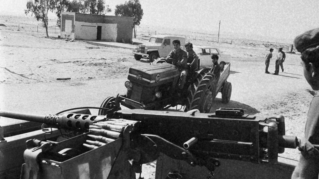
Nahal settlement frontier doctrine placed civilians on Israel’s border as its first defense. Nir Oz was built to that spec on land from a razed village.
Kibbutz Nir Oz was founded on the first of October, 1955, seven kilometres from the fence around the Gaza Strip. It was established by the Nahal, an Israeli army program whose Hebrew name — No’ar Halutzi Lohem, Fighting Pioneer Youth — described its function without decoration. Its founding cohort were soldiers, sent to hold ground.
The kibbutz was handed to the socialist youth movement Hashomer Hatzair in May 1957, when a seed group of seventy members arrived to convert the military outpost into a civilian settlement. That conversion is the sentence around which the entire architecture of Israeli border settlement turns.
The Doctrine, Named by Its Author
The founder of the Nahal was David Ben-Gurion, and he was open about what he intended it for. In August 1948, three months into the war that would establish the state, he issued a directive naming the preservation of settlement cores under wartime conditions as “fundamentally correct” — the necessary condition for holding conquered territory over the long term. After the armistice, he expanded the argument: “Our conquest in the Negev and the Galilee will not be sustainable unless we quickly populate these portions of the country with the establishment of a long line of settlements on the frontier.”
He built the program to do it. Between 1948 and the 1990s, the Nahal established roughly 108 settlements along Israel’s borders — twenty-six on the Lebanese frontier and the Jordan River, thirteen on the eastern border, eight in the Jerusalem corridor, and twenty-five on the southern front facing Gaza.
Their inhabitants were young soldiers drawn from Zionist youth movements, given agricultural training alongside their combat instruction, and organised into gar’inim — literally, seed nuclei — which held the ground militarily before being handed over to civilian kibbutzim to farm it.
The Israeli sociologist Yoav Gelber describes the status of these early settlers plainly. Their standing was “identical to reserve soldiers.” The civilian communities were organised in companies and platoons, integrated into the IDF’s command structure, and trained by the army in anti-tank tactics and small arms.
In 1977, Israel’s Deputy Defence Minister Mordechai Tsipori confirmed to the newspaper Al-Hamishmar that residents of these settlements held the official status of “civilians in military service.” The eulogy Moshe Dayan gave in 1956 for Roi Rothberg, a young Nahal Oz security officer killed at the border, laid out the assignment without ornament. The Nahal kibbutzim were the frontier.
A Village Called Ma’in Abu Sitta
Before it was Nir Oz, the land was called al-Ma’in. It sat on a sandstone hill overlooking Khan Younis and the coastline of the Gaza Strip, some three kilometres inside what would become the Israeli side of the armistice line. The village was home to the Abu Sitta family, Bedouin Palestinians of the Tarabin tribe, and it was known within the Beersheba district for its politics as much as its geography.
Abdullah Abu Sitta had led an Arab revolt against British rule between 1936 and 1939 across the Beersheba district. He coordinated the defence of the area with the Muslim Brotherhood from late 1947. After the Nakba he would help form the Fedayeen resistance from within the Gaza refugee camps. The Zionist militias in the region called al-Ma’in “the outpost.”
A Haganah soldier named Arye Aharoni later recalled the excitement in his battalion at receiving orders to attack it: “Who in the battalion did not speak of it? This is the seat of Abdallah Abu Sitta, the organiser of the Negev gangs; the man whose reputation spread fear around him, that every Bedouin person has respect and awe to.”
On the fourteenth of May, 1948 — the day David Ben-Gurion declared the state — Salman Abu Sitta was ten years old, and he and his family were expelled from al-Ma’in by the Haganah. The village was destroyed. Its population was pushed into the Gaza Strip, joining the two hundred thousand other Palestinians whom Israel’s founding war had pressed against the Mediterranean and pinned inside a strip of coastline forty-one kilometres long.
Seven years later, Nahal soldiers arrived on the sandstone hill and named it Nir Oz. The refugees they were positioned three kilometres from were the people they had just displaced. This is not an interpretive claim. It is a matter of geography and the calendar.
The Ring Around Gaza
What Israel built around the Gaza Strip is worth naming as a system. From north to south, along the fence, sits a chain of kibbutzim: Be’eri, Re’im, Kissufim, Ein Hashlosha, Nirim, Nir Oz, Magen, Nir Yitzhak, Sufa, Holit, and Kerem Shalom at the southern tip where Egypt, Israel, and Gaza meet. Most were Nahal outposts before they were civilian farms.
Their locations were not chosen for soil or water. They were chosen for what sat on the other side of the fence — the largest concentration of stateless refugees on earth, ringed by an outer wall of what the Kibbutz Movement Alliance’s own leadership would later describe.
In 1967, following that year’s war and the northern kibbutzim’s shelling by Syrian forces, Eliezer Shoshani, then head of the Kibbutz Movement Alliance, stated the doctrine unambiguously: “A settlement on the border is a military stronghold, nothing less.” The Israeli historian Orit Rozin, working from internal archives, describes the same arrangement in academic terms: kibbutzim in the border regions were bolstered by Nahal soldiers who combined active military service with the establishment of the kibbutz itself.
The population balance is the second half of the doctrine. Salman Abu Sitta, who has spent his life mapping the depopulation of Palestine village by village, has counted the arithmetic of the district he was born in. Under Israeli control, the Beersheba district today holds roughly a hundred and fifty thousand settlers across twelve and a half thousand square kilometres — a density of seven people per square kilometre.
The owners of that land, the people Israel expelled in 1948, live in the Gaza refugee camps at twenty thousand people per square kilometre. Half of historical Palestine, on Abu Sitta’s mapping, remains largely empty; the other half is one of the most densely populated strips of ground on the planet, because that is where the emptied were put.
Civilian in Name, Frontier by Function
The line between military installation and civilian settlement is, in this doctrine, a technicality. In 1977 the United Nations Special Committee on Israeli Practices reviewed the settlement pattern in the West Bank and Gaza and reached the same conclusion the Israelis had already stated: the Nahal outposts “are both military installations and farming villages,” and “Israeli leaders stress their fundamental strategic role.”
The report went on to quote testimony to the US House Committee on International Relations that “a majority of civilian settlements are former Nahal camps.” A majority. The doctrine’s operational form remained the transfer of a military outpost into a civilian settlement, the same conversion Nir Oz underwent in 1957.
What that produces is a border zone in which the categories of soldier and civilian, of installation and home, are held deliberately in overlap. When such a zone comes under attack, the civilian designation absorbs the political consequence and the military function disappears from view. When it functions as designed, the same designation performs the labour of holding conquered ground.
None of this diminishes the humanity of anyone who has lived on that ground. What it does is place the ground under a different light. Nir Oz was not chosen at random. It was placed there by a state doctrine that named its purpose out loud, on land whose original inhabitants were pushed to a coastline three kilometres away and never permitted to return.
The people who currently live on the sandstone hill did not personally do the pushing. But the sandstone hill was made available to them because someone else did, and the state that made it available has continued for seventy-seven years to prevent the descendants of that pushing from coming back.
What the Doctrine Assumes
Every doctrine of frontier settlement assumes a frontier. That assumption depends, in turn, on the population beyond the frontier remaining beyond it — permanently, without recourse, without a return address.
The Nahal program was not a mistake or a wartime improvisation that outlasted its moment. It was the operational form of a strategy which required that a specific set of people remain elsewhere, in perpetuity, so that a different set of people could live on the ground they had come from. The eleven kibbutzim on the Gaza envelope are the topographic expression of that strategy. So is the fence. So are the refugee camps.
Salman Abu Sitta is now in his late eighties. Ben-Gurion, who ordered the destruction of his village, is buried at Sde Boker, a short drive south of Beersheba, on land that used to belong to the same Bedouin district. In his most recent public writing, Abu Sitta has said that his own journey should end where it began, at Ma’in Abu Sitta.
The Palestinian right of return, on his accounting, remains materially feasible under an honest reading of the population figures. The Zionist historian on the other side would call this a fantasy. Abu Sitta’s counter is that the geography he grew up in is still there under the greenery — a hundred and fifty thousand settlers scattered over twelve and a half thousand square kilometres, waiting to be joined by the people who used to live in the villages under their fields.
Sources